 43
43

A free on-site soil check can stop a landowner from trying to dig a pond in a bad place
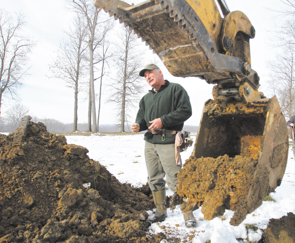

Stephen Prebonick, a state soil scientist, analyzes soil to determine whether a proposed pond site has characteristics that will allow a pond to hold water.
WASHINGTONVILLE
A free soil analysis could save a landowner contemplating pond construction plenty of money and headaches if it discourages the landowner from trying to dig a pond in a place that won’t hold water.
Stephen T. Prebonick, a state soil scientist, and Todd Miller, district technician with the Mahoning Soil and Water Conservation District, recently demonstrated this when they provided a two-hour, on-site consultation to the owner of a Green Township grain farm.
That landowner, who asked not to be identified for this story, wanted to create a pond to retain water to keep crop land dry, or to irrigate crop land, as needed.
The landowner used a backhoe to dig two test holes, 75 feet apart, one to a depth of 15 feet, and the other to a depth of 12 feet, with Prebonick examining soil samples as they came out of the ground, and Miller recording the results.
Prebonick gave the landowner the bad news that pond construction wasn’t desirable in the proposed location because the soil didn’t have enough clay content to retain water and because the soils deep in the holes couldn’t support the weight of pond construction equipment.
“There’s no point in spending thousands of dollars on a pond that’s not going to hold water. ... He may be a little disappointed, but he’d be a lot more disappointed if he spent thousands of dollars and then had failure,” Prebonick said.
“You’ve got to have the right types of soils to be able to hold that water,” Miller said.
Soil characteristics, terrain contours and watershed size all play a role in determining the likelihood of a proposed pond holding water, Prebonick said.
Prebonick, who works for the Ohio Department of Natural Resources, does soil analysis throughout the eastern half of Ohio and provides written reports of his findings from each inspection to SWCD and landowners.
Those wishing to arrange for a site visit by the soil scientist should call the Mahoning SWCD at 330-740-7995.
SWCD will check for the presence of underground utilities before any digging occurs, Miller said.
In Northeast Ohio, soil characteristics vary greatly from one spot to another because of the massive continental glaciers that scoured the land and churned the earth and rocks beneath them.
“Within just a few feet, you can have a drastic change in soil materials,” the state soil scientist said.
The glaciers, up to a mile thick, advanced southward to the Lisbon area during the last Ice Age that ended about 20,000 years ago, Prebonick said.
Soils with a high clay content are most conducive to pond-water retention, but sandy, gravelly and silt-laden soils aren’t conducive to water retention, he said.
Prebonick advises avoiding pond construction near bedrock to avoid having water leak out along the top of the bedrock or through cracks in the rock. “I don’t like it anywhere near bedrock,” he said.
Ponds can serve many purposes, including aesthetics, recreation, and water supply for homes, livestock, irrigation or fire suppression.
The soil scientist asks landowners to have excavating equipment ready to dig test holes at least 2 to 3 feet deeper than the proposed pond bottom in his presence, so he can examine soil samples as they are removed from the ground.
Prebonick can advise the landowner whether building a dam would be necessary or desirable for a pond proposed for a particular site.
U.S. Army Corps of Engineers permission is needed to dam any stream that appears as a blue line on a U.S. Geological Survey topographic map.