 43
43

Trumbull Co. nature plan faces snags
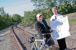
From left to right: Metro Parks Board Member, Dave Ambrose, and Trumbull County Planner Jonathan Millea say they have 4 phases left in Trumbull County and are hopeful that the bike trails will be done in three to five years in this area.
By Ed Runyan
AT A CROSSROADS
Completing the Western Reserve Greenway is the more immediate goal.
WARREN — Picture a hiking and biking trail entering Trumbull County just north of Newton Falls and following a railroad bed east to Warren, meeting up with another major hiking and biking trail that runs north and south near Diane Sauer Chevrolet and then continuing all the way to Washington, D.C.
And then picture people — local residents and tourists — enjoying nature while using those trails, plus canoe trails all over the county and about 1,000 acres of park land in 15 locations.
These are a few of the big and small ideas contained in the 193-page comprehensive plan being finalized by the Trumbull County Planning Commission and MetroParks Board.
Dave Ambrose, a MetroParks member, said the board will continue to make minor changes to the plan in the coming months, but it is mostly complete.
If the plan had a theme, it might be Trumbull County recreation at a crossroads.
Not only does the plan show the possibility of the county’s becoming the crossroads for the mostly complete Western Reserve Greenway bike-hike trail and the farther-off Western Reserve Heritage (bike-hike) Trail, but it shows that Trumbull has some decisions to make on how important recreation and land preservation should be to the life of its citizens.
Jonathan Millea, hired by the planning commission in July 2007, spent about a year gathering all of the data available on the county’s natural resources — its lakes, river and publicly owned land — and presenting suggestions for how they could be used to provide residents with quality-of-life amenities.
While the plan is being completed, the planning commission is itself at a crossroads, as Millea has left for a new job in Cincinnati; the planning commission’s director, Alan Knapp, retires at the end of the year; and the plan is turned over to the MetroParks Board.
The plan will be available on the MetroParks Web site in the coming weeks at www.metroparks.co.trumbull.oh.us, Ambrose said.
Ambrose said obtaining large tracts of land in recent years through funding from the state Clean Ohio grant money and the completion of the comprehensive plan leave the MetroParks Board and county at an important crossroads.
“We see the MetroParks at a critical point,” he said. The county commissioners have supported development of the parks by helping to fund the comprehensive plan acquire land.
Now, with only a few part-time employees and volunteers maintaining and developing the parks, the MetroParks Board must decide how to proceed.
The comprehensive plan discusses the possibility of asking voters for a levy to provide more staffing. Portage County voters will see a 0.5-mill parks levy in November that would raise $1.7 million annually for 10 years.
The county’s Western Reserve Greenway has been one of the MetroParks’ most visible parks and most prized accomplishments in recent years.
The former Penn-Central rail bed provides 14 miles of paved trail and is part of the north-south Great Ohio Lake-To-River Greenway, which will eventually link Lake Erie and the Ohio River and connect the Trumbull portions to the Mill Creek MetroParks Greenway.
Several phases of Trumbull’s trail were completed within the past five years, with remaining sections in and around Warren and Niles expected to be finished within several years.
An east-west route — the Heritage Trail — that would intersect the Western Reserve Greenway just south of Diane Sauer Chevrolet at U.S. Route 422 and state route 169 in Warren, is less certain, planners say.
It would follow the former Conrail (Erie-Lackawana Railroad) line, which was an important freight route between Cleveland and Youngstown but is now abandoned. Warren owns some of the land.
If the trail were established in Trumbull, it would connect with the seven-mile crushed limestone Headwaters Trail in Portage County that runs from Mantua to Garrettsville just west of Trumbull.
The Heritage Trail could someday connect Trumbull County to the Portage Hike and Bike Trail, which runs between Ravenna and Kent, and the Towpath Trail, which runs from Akron to Cleveland, planners say.
The Western Reserve Heritage Trail would run through the Thomas A. Swift Metropark in Braceville Township and Canoe City MetroPark in Leavittsburg before it meets up with the Western Reserve Greenway in Warren.
In that sense, the Heritage Trail also could connect with another of the plan’s ideas — a canoe trail on the Mahoning River would possibly span 23 miles in Trumbull County when complete. The first phase is likely to be from Swift Park and Canoe City.
From Diane Sauer Chevrolet, the Heritage Trail would meet the Warren Bikeway and Niles Greenway before branching off from the Lake To River Greenway onto another proposed route called the Mahoning River Corridor Trail through Youngstown.
There it would meet a trail near the Ohio line called the Stavich Trail.
The reason so many bike-hike trails have been built in recent years is because rail lines have been abandoned as freight shipping has moved to highways and airports.
Knapp noted that U.S. Rep. Tim Ryan of Niles, D-17th, has proposed that a high-speed rail system be created along the same abandoned rail line that the Heritage Trail would use.
The Western Reserve Greenway will remain the county’s highest priority hike-hike trail project, Knapp said, but even if high-speed rail service does come, it’s possible for a trail and rail to co-exist, he said.
Besides the Greenway and Heritage hike-bike trails, Millea has outlined several trails, such as Howland Township’s new Mosquito Creek Boardwalk Trail, which is 750 feet long so far and accessible through Howland Township Park at the end of Clifton Avenue; and 20 miles of foot trails on the southern end of Mosquito Lake.
Hiking trails also are available in Warren’s Packard and Perkins parks, as well as Girard-Liberty Park near Interstate 80, and in downtown Newton Falls.
Before writing the plan, the planning commission had public meetings. Residents said they wanted more trails.
“Greenways [hike-bike trails] have the ability to serve vast populations as they stretch from community to community, adding a new dimension to recreation and even transportation,” Millea wrote in the plan.
runyan@vindy.com